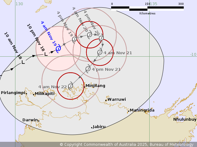
Published on Wednesday, 19 November 2025 at 9:53:02 AM

Tropical Cyclone Fina has formed north of Darwin and is currently moving slowly to the east-northeast, away from the coast. At this stage there are no warnings, watches, or alerts in place for the Northern Territory.
Current Status
-
Intensity: Category 1
-
Winds: Sustained winds near the centre at 75 km/h, with gusts up to 100 km/h
-
Location: Within 35 km of 9.7°S, 131.6°E, approximately 315 km north-northeast of Darwin and 195 km north-northwest of Minjilang
-
Movement: East-northeast at 9 km/h
Tropical Cyclone Fina is expected to intensify to Category 2 by Wednesday night. Later on Thursday it is forecast to turn south and then southwest, moving closer to the Northern Territory coastline with the potential for impacts on Friday and Saturday.
Hazards
At this time, no impacts are expected within the next 48 hours for any Northern Territory communities, including the Tiwi Islands.
Recommended Action
NTES advises residents to:
-
Stay informed through official updates
-
Follow all directions from emergency services
-
Keep emergency plans and supplies ready, especially as the system tracks closer later in the week
Forecast Positions
| Time (ACST) |
Category |
Latitude |
Longitude |
Accuracy |
| 3 am Nov 19 |
1 |
9.7°S |
131.6°E |
35 km |
| 9 am Nov 19 |
1 |
9.5°S |
131.9°E |
60 km |
| 3 pm Nov 19 |
1 |
9.3°S |
132.2°E |
75 km |
| 9 pm Nov 19 |
2 |
9.2°S |
132.5°E |
90 km |
| 3 am Nov 20 |
2 |
9.2°S |
132.8°E |
105 km |
| 3 pm Nov 20 |
2 |
9.3°S |
133.2°E |
150 km |
| 3 am Nov 21 |
2 |
9.8°S |
133.1°E |
190 km |
| 3 pm Nov 21 |
2 |
10.5°S |
132.7°E |
225 km |
| 3 am Nov 22 |
2 |
11.1°S |
132.1°E |
240 km |
Next Update
The next Forecast Track Map will be issued by 10:30 am ACST on Wednesday.
Back to All News